2001
Tue Sep 4 - Leave SonRise Marina, Sandusky Ohio, Lake Erie at 4am for Port Huron. Fueled in Detroit. Stay at Municipal Seawall tie up by the "Bowl-0-Drome" & Zebra Bar in Black River in Port Huron. Lunch at the Quay St Brewery, and got out mail and fedex's. 16 hrs.
Wed Sep 5, Port Huron MI - St Clair River - Get things done in morning. Fuel & Leave Port Huron about 2pm into Lake Huron. Weather great. Seas calm. Sunny but chilly. Originally heading for Presque Isle, but decide in the evening to continue on to Mackinac Island. Lisa & I trade watches all night. Sammy dog sleeps with Jessica, Cassie dog hides in her usual spot in the mid stateroom & never comes out while underway. Lisa gets mad at me at night when it's calm & I go out on the bow with a chair and a pillow to stand my watch while the autopilot steers (flat calm water - not rough at all). She comes out and doesn't see me and gets panicked that I've fallen off, before she finds me. Had to promise her I wouldn't do that anymore on my watch at night. (maybe with my SOSpenders & a harness tether???? - the stars are great from the bow at night way out on the water).
Thu Sep 6 - Mackinac Island, Michigan, Lake Huron. Still at sea off the western coastline of Lake Huron at 0900, and abeam Rogers City MI. Waves picked up some but still comfortable. Sunny & 65 degrees. Docked at Mackinac Island at 1:45 PM. This is the NORTHERNMOST point in our Great Circle trip. We are located at 45 50.993N and 084 36.917W. This is 1,279.72 nautical miles - as the crow flies - from home in Boot Key Harbor, Marathon Florida - but about 2,220 nm for our actual route. When we get pictures back from this old Victorian style Island town we'll post them here. 23 Hours from Port Huron and last fuel.
Fri Sep 7 - Mackinac Island at dock. Rained a lot this morning so stayed on boat and worked. It's a little more awkward to work from here - though the cell phones work - the computer won't go through them - so have to walk to the payphones and hook to the dataport. Fronts moving through. In the afternoon took a couple hours for a horse-drawn carriage tour of the Island. Jessica is in to all the horses here. We may be far removed from the Florida Keys, but the tourist theme is prominent in both places. Tonight we'll probably have dinner in the Grand Hotel with Jessica, then leave tomorrow am for Mackinaw City to resupply and visit with Bill & Jan Morrison (PDC for powersquadron folk). Went up to the Rotunda bar for drinks overlooking the lake at the Grand Hotel with Jessica, then down to the main dining room for dinner - great. Four piece jazz band, good food (I had pheasant) and great ambiance. We splurged since this may be the only time we can ever do this.
Sat Sep 8 - Mackinaw City, Lake Huron - In the morning at Mackinac Island, found leak in starboard water pump which has been pumping water into oil pan, then flooding bilge. Started to pump out but the oil exchange pump was seized. Ripped it all apart and starting rebuilding that electric pump before having to leave the dock about 12:00 . Head for Mackinaw City and get a slip there. Finish rebuilding the electric motor ( had it all apart down to the permanent magnets out of the casing), then pump out 15 gallons of oil and water from both oil drain pans. Clean up, then Bill Morrison picked us up for dinner at his and Jan's place. They have a great place right on the water overlooking the straights of Mackinac and Mackinac Bridge. 1 hr.
Sun Sep 9 - Mackinaw City, Pulled out the starboard seawater pump that had been leaking. Thought it was just the seal on the coverplate, but it's the internal seals and bearings - needs to be rebuilt, but no one available on Sunday so will have to wait until tomorrow to even order parts. That will put us behind some, but just as well since the weather is really blowing and stormy anyway. This is a good time to take a delay. Bill loaned us his truck and we went to Cheboygan to Walmarts and the Grocery to resupply. Of course there were no pet stores around, so we ended up driving to Petosky for crickets for the tree frogs, and Lisa picked up guppies for the turtle plus dog food (Lisa's ark). Went back to Bill and Jan's for another great dinner and company.
Mon Sept 10 - Mackinaw City. Will be here overnight again waiting for the water pump. Bob Darrow at Sheplers marine - friend of Bills - checked all over for us for a rebuild kit but couldn't come up with anything except a whole pump in New Orleans - and VERY expensive. Had him order the pump and it should be here tomorrow. The weather is clear now but cold and very windy so the timing of the delay is still good. Will just get more regular work done and try to head out tomorrow. Going back over to Bill & Jan's tonight for dinner. They've been very gracious in hosting us while we're here, and it's especially nice to have friends in a place when you're here like this for a while. Temperature now is only 63 degrees - so wearing sweaters and long pants.
Tuesday Sept 11 - Mackinaw City. Today is my mom's birthday. This morning the terrorist attacks occurred in New York and Washington on the Trade Center and Pentagon. We essentially sat and watched most of the morning on satellite TV. Everyone in the marina and office did the same. My water pump did arrive by early afternoon. Since all US flights had been shut down I'm glad it got on one the night before to get here. We got the pump installed and off the dock by 3:30pm over to the fuel dock and topped off. It was $1.75/gallon. Just as the attendant brought back our charge slip to sign, he said we were just in time. He'd just received a call to TRIPLE the fuel prices - based on the terrorist attacks and anticipated lack of foreign fuel!! $5.25 per gallon! This will kill us on the trip back home. I hope we can find reasonably priced fuel supplies. Left the fuel dock at 4pm and proceeded to the center span of the Mackinaw bridge. I called Jan and Bill on the cell phone to let them know we'd be passing by their house on the straits shortly. Then we spotted the coast guard coming straight at us from under the bridge. I told Jan and hung up the call. She and Bill were able to watch through binoculars from their house. The coast guard came roaring up directly to our bow - would not even come alongside - blocking us. A crewman armed with a shotgun at the ready stood by on the bow. I tried to maneuver to come alongside them to talk, but they kept blocking me. I had to leave the boat adrift and walk out on the bow to talk to them. They would not let us pass under the Mackinac bridge - only commercial traffic - and only 100% US Citizens and registry. We were forced to turn around and head back to Mackinaw City marina. It made no difference to them that the boat is federally documented (part of the US Navy) and I have a USCG 100 ton captains license (have to have police & FBI background checks and fingerprinted). Bill Morrison called me on the VHF enroute. I told him we'd be over again tonight for dinner - get the beans and brats ready! Jessica was happy to go back to their place. I checked the GPS and digital charts as we got back to the dock. THE GPS IS 2 3/4 MILES OFF TODAY!!
Weds Sept 12th - Mackinaw City. The day after the world has changed as we know it. I just hope we don't surrender too many of our personal freedoms of an open society in the name of collective security. Lisa was up by 4am looking at the news, and I got up by 5 or so. We took out our video of our boat trip up North here and looked at the New York City passage, with the World Trade Center prominent in the video - May of this year. It's just after 7am now and I just talked to the Coast Guard in St Ignace. They'll let us pass today with the caveat that we must be US or Canadian citizens and the same registry on the boat. We'll go. The problem though is that we missed our weather window and it's blowing hard again. Seas will be rough. The nearest port is Petosky and that's more than 6 hours away for us. Would be nice if we could run all day and night - but depends on seas - and then on where we might be able to refuel at an affordable price. I'm posting this from the marina office phone lines before we depart. Don't know when we can transmit again since cellular service for the computer doesn't work in the "wilds" of Michigan.
--- departed Mackinaw City by 9am - the coast guard boat approached us, then circled and stayed with us about 3 boat lengths off our starboard quarter without ever saying anything to us. He escorted us under the bridge, then turned and ran back once we were through. Jessica wanted to know if they had guns again. She thought they had been pointing them at us, so we told her they hadn't. She had watched the Trade Centers burn down in real time and all the people hurt, and we had to explain a lot to her. Now she's worried about guns. This is another turning point in our Great Circle trip. Today we will actually be starting to head SOUTH again to get back to the Keys. The weather got ROUGH! but there was no way we were going to go back and risk not getting through again. 4-6' seas in the straights - off our bow, then building to 5-7'. Got really banged around. Even the dinghy flew out of its cradle & had to go above to secure it. Bow was digging under the waves when we came off the top of the big ones. Turned tail and headed for the nearest harbor of refuge - St James Harbor on Beaver Island. The only US Island that had it's own King - originally settled by Mormoms, then Irish settlers. We anchored and stayed put, waiting for weather to subside. 5 hour run from Mackinaw to Beaver Island. We got behind on the schedule - first because of the repairs on the water pump, then the coast guard blockade, now the weather.
Thur Sept 13th - St James Harbor - Beaver Island, at anchor, Lake Michigan. Weather is not getting any better. Thought it might, but not until tomorrow. Will stay at anchor here another night. At least getting a lot of work done while waiting. Only problem is that the cell phones don't work out here. Lisa is worried about the Cuban turtle. Seems he ate a rock while foraging for food on the bottom of his aquarium. I told her there wasn't much we could do. He'd either pass or regurgitate it, or die. I wasn't going to have emergency surgery done on the turtle for a swallowed rock. We'd just have to trust in mother nature. It's COLD up here though !!!!! Running the heaters, then turn them off at night, close all the hatches and doors, and snuggle down under the covers. At least Jessica has the 2 dogs in sleeping with her to keep her warm. Lisa keeps me warm. LOTS of starts out here at night, if you can stay warm to watch them.
Fri Sept 14th - St James Harbor - Beaver Island, at anchor. Weather finally calmed down! Out of harbor about 8am. Waves less than 2' and a following sea. Comfortable ride. Stopped in Frankfort Michigan for fuel about 5pm. Jessica played in the park and the sand while we were there. Fuel was "only" $1.81/gal - so good. Headed toward the open Lake and Chicago. Weather is supposed to be calm with waves less than 2'. Waves are picking up and the sea is NOT what is forecast. Now getting 2-4' and choppy. Cold too! Have my orange hunting toboggan on, with my Greek fisherman's hat over it, and wearing gloves, a turtleneck, sweater and coat! Barometric pressure has dropped 0.1 inches in 3 hrs. 8:10 pm - We're turning around - to head back to Manistee and find an anchorage for the night. Anchored just inside breakwall by 9pm in the dark. Really ROUGH in here - thought it would be protected. The waves and wind are coming from different directions so it's rocking us like crazy - go out with Lisa with a line to warp the boat so it's sideways to the wind and head-on to the waves - MUCH better. 13 hours run for day, 3 hrs 45 mins since fueling.
Sat Sept 15th - Manistee MI at anchor in the breakwall. Weigh anchor at 0630 in the dawn twilight - all the fishing boats going out (but just past the breakwall). Lisa reluctant to make an overnight run to Chicago when the weather forecast is in question. Heading down the coast of Michigan to South Haven. Waves still 2-4' and we're in the lee of shore. 3:15pm - water flattening out now - this is what it was supposed to have done for the last 2 days. Decide to change course at 3:45pm to head directly for Chicago - will arrive after midnight. It's COLD. Have been reading Bahamas articles and looking at those charts just to keep psychologically warm! Chicago skylight is even better than New York Cities coming across the Lake, because you can see the entire city. Just off the city about 12:30 am (11:30am Chicago time). Head into Burnham Park Harbor just behind Meigs field - going in by radar. We have a slip at the Yacht club at the North end, but it's too dark and too many boats in here to do this for the first time. Drop anchor just inside the harbor beside McCormick place about 1:15 am Eastern Time between the first docks and mooring field. Will go to the marina tomorrow. View is great from here. 18 hours 45 minutes run for day.
Sun Sept 16th - Chicago, Burnham Park Harbor by Meigs Field, Lake Michigan. Up to watch the sunrise about 6:30am Chicago time. Am setting clocks back now on boat, computer and GPS. This is the first time I've ever gone that far west in the boat to change time zones. Will meet up with Keith and Sarah and the kids today in Chicago. Cell phones are working again now too. Move to Yacht Club at North end of harbor by late morning. Took Jessica to the Shed Aquarium in the afternoon, missed Keith & Sarah since they had to get back to Cleveland. Penny Smalley, husband Ivan, son Jeffry and daughter-in-law Lisa came over to the boat early evening for wine/cheese on the back deck. Nice evening, but they had a heck of a time getting past police barricades into the harbor (it's also Meigs field downtown airport). Can't believe that we're essentially still under Marshall law since last week's attacks. The Yacht Club manager was surprised we didn't get rousted from the anchorage by police, and said there were now many restricted waterfront areas, and restrictions on boats.
Mon Sept 17th - Chicago, Burnham Park Harbor Yacht Club. Worked in the morning, meet with Pat Moriarty and have lunch with him and his wife Marsha. The Sears tower is prominently seen from our slip - along with the rest of downtown. We talked to Jessica about going up in the Sears Tower on the observation deck and she is very quick and very adamant to say "No Way" that she wants to go up there. She remembers the live TV coverage of the World Trade Centers coming down and all the hurt people.
Tues Sept 18th - Chicago, Burnham Park Harbor Yacht Club. Work all morning. Take Jessica to the Adler planetarium which she really liked - lots. Had lunch back at the Yacht Club, then over to the Field Museum to see the Dinosaur Skeletons & Egyptian Mummies, etc. before they closed. Jessica didn't really care for all that though. Back to boat just before it starts raining. Leaving tomorrow down the Illinois river, but it will be raining most of the day and many bridges and locks to work. (Poor Lisa - she's the one that has to be out on the bow getting rained on, since she won't pilot the boat through the locks!).
Weds Sept 19th - Chicago, Burnham Park Harbor Yacht Club, Lake Michigan. Rained HARD all night & blowing. Settled down some by midmorning but still drizzly and blowing some. Left about 10:45 to head in to Chicago River through the lock on the harbor. Going through downtown Chicago, right under Michigan avenue, was GREAT. Great view. Bridges were VERY low but made them without opening. After downtown though it wasn't nice. They shouldn't call it the Chicago Sanitary ditch - it should be the Chicago UNSanitary ditch! The smell was terrible. Lisa even pointed out the dozens of condoms that were all over the river for miles downstream. This was boating in a toilet - almost literally. Barge traffic has been extremely heavy. Have been in three really tight places with them already - very narrow clearances in the middle of opposing barges and tugs, and fighting the strong propwash from all of them with no room to maneuver. Sometimes they had the canal completely blocked and we had to wait to squeeze around. Made it to Lockport lock by 4:30pm and waiting for lock through, but by 6:30pm we gave up and asked them if we could just stay on the lockwall for the night since it would be getting dark. 6 Hrs running
Thurs Sept 20th - Seawall tieoff at Lockport Lock, IL, Illinois River. Got started just before 7am, but big barge came into lock just before we called - have to wait again for a while. In the next lock we rafted up to a BIG barge. It made it easy to go down. But it was a GARBAGE BARGE from Chicago. YUCK! We didn't tie up to the barge where we were told - stayed back some from the front. Glad we did. It turned out they had a high capacity pump, pumping out water overboard from the bottom of the Garbage Barge. If we had tied where we were told it would have been pumping garbage water all over our decks and into the galley windows! Had another lock downstream have us change sides of the fenders and fender boards THREE TIMES in close succession - talk about a Chinese fire drill. Another had us tie up to a round island with one bollard in strong wind (VERY tricky to say the least, and several lines) - and then immediately called us to hurry on in to the lock - we had to fight the wind and lines to get free and they kept calling us to hurry up. It would have been just easier to hover to begin with. I earn my title of Captain Crunch AGAIN - forgot to lower the antennae after the first lock this morning and cracked the top portion of it under the next bridge (this is the THIRD time I've crunched my antennae - but I can fix it). DANG! THEN, in one of the Chinese fire drills, I had my cell phone on my belt and crunched the display case cover while working on deck. They don't call me Captain Crunch for nothing! About 5:30pm decided to just head in to Starve Rock Marina upstream of the next lock. Found a slip and went to dinner there with Jessica. 9 hrs 35 mins run.
Friday Sept 21st - Staved Rock Marina, Illinois River - Out of Marina by 0800 and in to Starve Rock Lock by 0830. Cruising today with the boat Tena Rose who we went through the last lock with, and met at dinner last night. The river down this way is MUCH nicer than close to Chicago. The Starved Rock area is very scenic. Made it in to Peoria Illinois on Peoria Lake by 2:30pm and have a storage slip for a month. We'll have to secure and leave the boat while I work in Ohio, Michigan, and then back to the Keys before returning to pick up the boat. If you're coming with us for any of the trip we should return to Peoria by around Oct 16th-18th and continue on down to St Louis, then the Tennessee River through Kentucky, AL and MS. Jessica lost her two front teeth while here! 6 hrs 30 mins run.
The slip at Seaway Marina is the tightest I've ever been in! Gunnales on both sides overlap the piers. Had literally inches to turn in channel to get in slip. Greased it in as a "force fit" - but VERY secure and tight.
Thursday & Friday Oct 18th & 19th, Seaway Marina, Peoria IL- Back to Boat with Lisa & Jessica, plus brother-in-law John Lockhart. Lisa & Jess will leave Friday to go back to Cols with family, and meet John and I in a week or so in Kentucky. Get boat ready and resupplied. Replaced one 31D battery on port engine battery bank.
Saturday Oct 20th, Peoria IL - 44 degrees outside! Time to go South !!! Depart at 7:30am down river. The locks are flooded over with high water so they let down the dam and we just go right over the dam in the middle of the river (how do they do that?). Got stopped by a USCG Auxiliary boat just south of Peoria - interesting. Put on lights and came alongside but didn't board. Didn't think the auxiliary had any authority to pull boats over or board. But pleasant enough - appeared as though a regular USCG was onboard too so I guess that would have given them the authority. He wanted to know who we were, where we came from and where we were going. Said they were routinely checking all boats now in the days after the bombings. Stopped at Rivers Edge boat club for fuel - interesting local place. Went up a small ditch off the river and tied to a rusty old barge with fuel tanks on it. We ended up staying the night - no elec or water. They had a restaurant/bar there and people were showing up by horseback to the bar. Nice people. I learned something new. If I had a horse that I kept at home, then went out with him and got stone drunk, he'd automatically take me back home if I could stay strapped on! -- Beats driving!! Everyone was going out to the Moose lodge in a town 30 miles away that night for dancing.
Sunday Oct 21st , IL River- Off barge and down river by 0710 - daybreak. Passed over another flooded dam & locks. Saw lots of storks today - have never seen them outside of a zoo. Made it to the Mississippi river by 1520 with John at helm. John's been piloting the boat while I do regular work, plus work on the rails of the boat for new varnish. Made it to Alton IL marina by 1640 to stay for the night. Fancy marina. We just stayed on the boat. It's right by the new suspension bridge that was built N of St Louis, and the night lighting was impressive.
Monday Oct 22nd Alton Marina, Mississippi River - Leave Alton at 0830 and enter the Alton locks - easy and quick, but got a log jammed in the rudders coming in to the locks - froze up the helm and had no steering. Finally took a chance and blew it out by putting the engines in reverse and revving the throttle - worked - lucky I didn't break something though. Met a couple of middle age+ guys in a canoe in the next lock at Chain of Rocks - they locked through with us. These guys had already been through 27 locks and had started from Minnesota on the Mississippi river. They are going all the way to New Orleans in that canoe! We'll have to watch for them in the news. Shared some coffee with one of the guys while we locked down. Went up the Kaskaskia river by about 1545 to find a place to stay for the night - no other place close enough down river to stay before dark. We wanted to tie up to the outer wall at the lock. The lockmaster told me that would have been OK before Sept 11th, but now he couldn't let anyone tie up to the lock walls for the night. We had to lock up and go upriver to anchor somewhere.
Tuesday Oct 23rd, Anchored Kaskaskia River off Mississippi - Weigh anchor abut 0735 and through the lock by 0840 and into the Mississippi again. We're getting a good push from the current downriver - both here and back in the Illinois river. Picking up about 3 mph or so. Around noon we got into heavy rain with lightening and thunder. Visibility went to zero at times. Made it to Cape Girardeau by early afternoon and tied up to a fuel dock (no elec or water) that Larry Haertling had helped arrange for us. Left the boat with Larry and went back to his place - saw an impressive animal trophy collection, then he took us to dinner at the Pilothouse. Got a short tour of town. It's nice to have friends in different ports.
Weds Oct 24th, Cape Girardeau MO fuel dock - Down river by 0730. John pilots while I work. At the junction of the Mississippi and Ohio rivers by 1130, and head upriver in the Ohio toward Paducah. Now we lose the extra speed and instead it slows us down about 3 mph. Wind is very strong and seas developed 3-5 feet in the river. Getting very sloppy. Went over more flooded dams. In the afternoon we got hit by a line of severe thunderstorms in the river just west of Paducah KY. We got hammered! It came extremely fast, with gusts that were blowing chairs and cushions off the boat. Seas whipped up immediately. We could see the black clouds barreling down on us from behind, and watched it on radar. We were in a bad spot by flooded locks and a submerged island that wasn't marked, and between bridges. We tried to get to a spot quickly where we could get off channel and anchor fast. John worked the foredeck while the boat was tossing in 5'+ seas - he snapped himself in at first to the safety lanyard on the bow pulpit. It was pouring rain and driven with 60-70 mph winds while John got our anchor set. I tried to maneuver the boat but the wind and current set us sideways to the seas - it was EXTREMELY rough. Lightening came all around. A towboat captain called out on the radio that there was a tornado just on the other side of the bridge from us, but we never saw it. We couldn't even see the bridge. The anchor held, and we held on til the line passed. We locked the two dogs down below during the storm - scared the crap out of them - LITERALLY! It was still raining and windy though even after it passed and it was very hard to pull the anchor in 30' of water (66 lb Bruce anchor with 75' of chain & 3/4 nylon rode). Finally got it up - John was about worn out - collapsed on the foredeck in exhaustion after securing the anchor - I had to yell at him to come back inside, since he was on the exposed deck and lighting was still hitting all around. Made it on in to Paducah and got help tying up in the rain to the barge docks in front of Executive Inn - no elec or water. Took John out to dinner at the Executive Inn - he earned it.
Thurs Oct 25th - Paducah KY - dock at Executive Inn. Up working again since 4am this morning. Waiting here at the dock for the shops to open inside at 9am. John lost his special hat in the storm yesterday, and he's going to get a new one, from the place where the other was lost. Then we'll head upriver to the Cumberland and make it into Lake Barkley tonight. Lisa and her sister Terri, plus all the kids, should join us late tomorrow night. Cold today, but uneventful. Anchored in Nickell Branch Cove in Lake Barclay by 1515. No waiting at the lock into the lake - 57' lift. This is the area of the "Land between the Lakes". It's really windy in here. The cove is protected, but winds are 25-30 mph from the west - and its cold. 63 degrees at 1630, and its supposed to hit FREEZING tonight!
Position 36 59.415N 088 17. 072W. 7746.8 ED.
Fri Oct 26th, anchored Nickell Branch Cove Lake Barkley KY - Generator broke down about 3:30 am last night and it was COLD outside - so got down and worked on it the entire night. Had to drill and tap a new mounting hole in the engine case for the water pump. Finished about 7:30 am. Weigh anchor by 0950 and head for Kentucky Dam Marina to meet Lisa, Terri and the kids. Winds are pretty strong - 25mph or more. We were protected in the cove while anchored but it's really blowing on the lake. Got a slip on the T dock at the marina - wind REALLY blowing us - got some help with lines to dock. Today's the last day that Pirate John and I are bachelor seaman. The ladies come tonight.
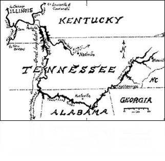
This is the start of the Tenn-Tom waterway. We're in Lake Barclay now, but when we cross over to Kentucky Dam (and through land between the lakes) we'll be in Kentucky Lake, which is the Tennessee River.
This is the approach to the Tenn-Tom Waterway - the TVA (Tennessee Valley Authority) built this. It is the single largest and most expensive project every funded by any government anywhere! (OK the pyramids might qualify for that, but no records exist). We left Chicago via the Illinois River to the Mississippi. We turned upriver on the Ohio River to around Paducah Kentucky.
We leave the Ohio River just upriver from Paducah Kentucky. Most people go directly into the Tennessee River and Kentucky Lake, but that lock gets pretty busy with commercial traffic so we went 20 more miles upstream to the Cumberland River. That lock is much quieter and we went right through into Lake Barclay where we anchored for the night. From there we cross over a canal into Kentucky Lake and proceed on down the Tennessee River to where it branches into the manmade Tenn-Tom waterway at the corner of Tennessee, Mississippi and Alabama. (We hear the cruise upriver on the Tennessee River through the mountains of Chattanooga and Knoxville TN is really nice - maybe try that one later).
Sat Oct 27th - KY Dam Marina, Kentucky Lake - Lisa and Terri got here last night about 3am with their mom Betty, plus CJ, Amber and Jessica, 2 black labs, 3 tree frogs, a Cuban turtle, 2 hermit crabs, crickets --- and a partridge in a pear tree --- ... Oh well, the peace and quiet is gone for John and I, but it's nice to have the families back. Just call this boat Lisa's Ark. Have to take one car to Pickwick Lake in TN today for crew to get back. Terri and Lisa went out shopping to resupply the boat. John and I made the 7-8 hr round trip drive through some of the most remote places of Kentucky and Tennessee we've ever seen to get to Pickwick.
Sun Oct 28th - KY Dam Marina, Kentucky Lake. Got up this morning and HAD ICE ON THE RAILS !!! This is getting WAY too close. We need to get moving and get back to where it's warm all the time. Had to bring in the deck plants and drinks last night because of the hard freeze. Very heavy fog this morning. Off fuel dock by 0940. The time changed last night so sun will set about 5pm . Entered Leatherwood creek in Kentucky Lake about 2:25pm to anchor. A quiet cove.
Position 36 22.111N 087 59.077W ED 7791.5.
Mon Oct 29th - anchored in Leatherwood Creek, KY Lake. Up at 0630. Very foggy. Weigh anchor and back in channel by 0712. Navigating by radar and giving security calls on 16/13 for tows. Saw a fox today at the rivers edge and got on video. Drop anchor after sunset at 1715 up Indian Creek - a spooky little small creek in Tennessee, with a shipwreck on the bank, and lots of small shacks and signs of people coming and going - but no houses and no one there now. Mile Marker 168.3 Tennessee River. Position 35 22.886N 088 08.615W, ED 7871.9nm.
Tues Oct 30th - anchored in Indian Creek, TN River, TN - Weigh anchor by 0630. Running slow in heavy fog with radar. Shot a goose in the butt this morning with a slingshot - but it just wiggled it's butt and kept on swimming - never even flew away (they poop on the swim platform). Did Pickwick lock today. Enter Pickwick State Park Marina about 1:13pm - this is where their car is and where their part of the trip ends. Betty, Terri and CJ ALL piloted the boat some. CJ learned how to stow fenders too. Amber and Jessica got "poop deck" duty by scooping up the dog poop from the bow each morning and flushing the deck. Met Kevin & Karen on the S/V Windigo II - coming from Minnesota and going to South America for an indefinite time! Kids went to a Halloween costume party in the evening at the park office and got candy. We all went out to dinner at the Lodges Restaurant for a fare-well dinner. Would not recommend the state park restaurant - most boats have better meals onboard - but the people were nice.
Weds Oct 31st HALLOWEEN - Pickwick State Park Marina, Pickwick TN - Last minute resupply trip with the car before John & Terri leave, then they left about 11am. We immediately departed to continue south down the Tennessee river to the tom-bigbee waterway. Arrive at it's junction with the Tennessee River at Yellow Creek around 12:30, then make our way through the straight, narrow, and historically and politically expensive, Divide Cut. The Tennessee Tom-Bigbee waterway project undertaken by the Tennessee Valley Authority is the single most expensive government project ever done! Made Bay Springs Lake in Mississippi and anchored in Sawgrass Marsh - Cotton Springs Branch, by 4:15pm. This is a very nice, small and cozy cove. Have anchor out almost on one shore, and the stern tied to a tree on the opposite bank of the small cover. Did this by dropping the anchor right at shore, then maneuvering the boat around the other way while Lisa stood at the bow pulpit with a line in hand. I could get the bow right up to the tree on the bank where she puts a loop around a branch. Then we back away and pull them both tight so we're right in the middle. This keeps us from swinging too so we can even tune in the Satellite TV for news. A full moon is out tonight (Halloween Night - the first full moon on Halloween in 46 years) and LOTS of stars in this remote wooded cove. Nice night. Jessica like it too.
Position 34 31.702N 088 18.870W, ED 7944.8nm.


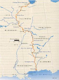
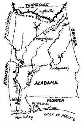
This is really the start of the Tenn-Tom Waterway. This first stretch as it branches off the Tennessee River and goes down through Mississippi is entirely manmade! It cost billions of dollars but pays for itself in the commerce on the River. Inland rivers connect such cities as Minneapolis MN, Chicago IL, St Louis, Cincinnati, Pittsburgh, Knoxville, Omaha NB and even Tulsa Oklahoma! They all get to the Gulf of Mexico through either New Orleans on the Mississippi (it's still about 120 miles to the Gulf from New Orleans), or Mobile Alabama.
We took the Tenn-Tom down through Demopolis AL, then on down to Mobile. This last stretch of about 200 miles from Demopolis to Mobile is almost entirely secluded forest. There are no facilities or fuel on this last stretch so one must be self sufficient.
Thurs Nov 1st - anchored in cove of Bay Springs Lake, Mississippi - Undo tie-up to tree just by undoing one end of line and pulling it back, then weigh anchor. Tropical storm Michelle is now South of Cuba and we have to watch it. Trying to figure out where we can stay so I can drive back to the Keys, for Eric and for the storm if it happens. Entering the Bay Springs lock about 0845. This is an 84 foot drop. This is a significant lock because it now begins our downward trek BACK TO THE SEA! This is the dividing point. Locked through with "Champaign Lady" from Ottawa Canada - a power squadron member who is taking their boat down to Sarasota for the winter. Made two more locks after Bay Springs. Pull into Blue Bluff Recreation area by Aberdeen MS around 4:30pm. The chart just shows an anchorage and boat ramp, but we found a small dock - unattended with no electric or water, but free. Nice spot. We walked the dogs and Jessica all over the recreation area and down to the river on the other side of the road. My sprint phone FINALLY works again here, but not the Nextel. It hasn't worked since Peoria - worthless. The trawler "Leaky Tikki" is tied to the dock with us, and they're heading to New Orleans for family.
Position 33 50.318N 088 31.718W, ED 7992.4nm .
Fri Nov 2nd - Tie-up at Blue Bluff Recreation area, Aberdeen MS - Michelle is now a Hurricane south of Cuba and heading for the Keys - where I'm supposed to be driving this weekend. Will head for Columbus MS today to see if I can get a car to go, and keep watching the storm. Got through Aberdeen lock by 11am. Lots of military jets flying over today, but I guess the Columbus MS AFB is nearby. Arrive at Columbus Marina early afternoon - jockeyed around with slips. Originally in a covered slip but couldn't get satellite TV, or the SSB for hurricane weather - so tied on to transient dock. Plan is to leave boat here with Lisa and Jessica staying aboard, but have to watch the storm. Had an electrical fire onboard at the dock in the afternoon - shut down all systems to trace it. Never found the exact problem but reason to believe it was a faulted switch on a 110v exhaust fan in the engine room - I disconnected all of it.
Position 33 31.305N 088 28.940W, ED 8013.3nm.
Mon 11/5/01 - Columbus Marina - Columbus MS - Have sat here at the marina on the boat all weekend watching Hurricane Michelle on the Weather Channel & deciding what to do. Can't get a rental car with unlimited mileage at any reasonable rate anyway. Michelle went by the Keys last night, and fortunately they just got lots of rain - no direct hit. Cuba got hammered though - think it was category III or IV when it hit. Met a sailor here by the name of Eric in the S/V Kimminnee who is going to Marathon for the winter. We shared the dock space for a while with Denny and Ruby in the M/V Boomer (named after their dog) who is also heading far south. It's at least getting up into the 70's during the day now, but still hitting the 40's at night - have to keep going south. Lisa likes this place - they're giving her free crickets for the frogs, and minnows for the turtle tank - Lisa's Ark expands! The people here are very friendly. We did get a rental car for one day locally and resupplied and went out to dinner.
Tues 11/6/01 - Columbus Marina - Columbus MS - getting ready to depart. This is the longest we've stayed somewhere on the boat (except maybe Mackinaw City?), and ready to go. Lisa stocked up on more crickets before we left. Phones have worked here. Hope it keeps up. Locking through with a large motoryacht "Elusive" among other boats today. He got the boat in the Chicago area and is taking it to San Diego through the panama canal. Have a professional captain aboard, and also a small child under 4 who likes to wave at us out the window. Anchored in the small Sumpter landing cove by 3pm. Mile Marker 270 on the Tenn-Tom. After anchoring Sammy dog just crapped on the carpet and Cassie dog peed over it! Could kill them! Elusive and Odyssy at anchor here too.
Position 32 31.597N 087 50.391W. ED 8110nm.
Weds 11/7/01 - anchored in Sumpter Landing Cove, Tenn-Tom waterway. Up at 0600. Very foggy and 40 degrees out. Having some coffee first. Weigh anchor by about 0640 and run in very heavy fog (can't even see the banks of the river) up to Heflin Lock. Elusive & Odyssy caught up with us before the lock doors closed. Arrive at Demopolis Yacht Harbor (Alabama) at 12:50pm. Went out to dinner at the marina restaurant. Have decided to stay an extra day here in order to get some work done, since phones do work here.
Thurs 11/8/01 - Dempolis Yacht Harbor - Demopolis Alabama - Up at 0500. Work all day, then go to Walmart & grocery to resupply with loaner car from marina.
Fri 11/9/01 - Dempolis Alabama - 0630 getting ready to depart. Finishing faxes & emails before going. Lisa found a GIANT spider this morning on the fender line as we departed the harbor (the one critter she won't take in as a pet). My job was to execute it and throw the carcass overboard. Locked through the next lock with a large tow - Whipporwhill, and had to be very close to the rear lock gates. Lots of small holes where spouts of water come shooting through the locked gates - Lisa wants to plug them all up. Saw our first sign of Spanish moss today, and turtles starting to show up all over. Turned in to a very small creek - Bashi Creek - about 2:35pm - not much point in running further because next closest spot to pull in would be well after dark, and we don't want to run in the dark if we don't have to. Dropped a bow anchor about 4 feet off the shoreline, then backed up to a tree and tied off the stern. Really nice spot, but this turns out to be a wildlife refuge, and we can hear hunters guns out in the woods around us. Jessica has been wearing her Halloween outfit of some sort of striped cat, with tan and black stripes, with animal ears and a long furry tail. We made her change clothes to play on deck since we didn't want some excited hunter half seeing her through the sees and getting a shot off at her! Another boat - Misty Sea - showed up after Sunset. This is a WHOLE OTHER STORY - this guy bumbled down the river with us all the way to Mobile Alabama. It's too long a story to list in this log, so if you have time to read it, CLICK HERE for the Rest of The Story - of Misty Sea!
Position 31 57.316N, 088 04.248W, ED 8168.7nm.
Sat 11/10/01 - Bashi Creek, Alabama. TennTom Waterway. Up at 0230 this morning. Might be able to be home by my birthday on November 26th. Talked to Joe Thomas from Mobile, and might be able to pick him up for the rest of the trip to Mobile at Coffeeville Lock this morning. At 0646 we're still waiting for the heavy fog to lift some before departing. Finally have to leave by about 0848, and the fog is still quite heavy. If we delay much more there will be no place to anchor tonight. Depart the creek into the river navigating solely by radar and making securite calls on the VHF radio for tows and barges. Misty Sea was following us out, but we lost total contact with him - never did see him on radar departing the creek. By about 10:15 or 10:30 am the fog had lifted and we were happily cruising down a wide part of the river past a small fuel dock called Bobby's Fish Camp. Coffeeville Lock was still well up the river. The cruising guides said something about the people at the fuel dock always enthusiastically promoting their fuel and services to passing cruisers on the VHF and from the dock. I wasn't wearing my glasses as I sat at the helm going by - we must have been a hundred yards or more off the dock. I saw a man standing there by the fuel pump and he started waving his arms at us as we approached. I kind of ignored it but he kept it up with vigor. I finally got on the Loud Hailer as we went by and told him we didn't need any fuel, but thanks anyway. We cruised on by. As we got far enough down the river that the open part of the aft deck now faced back toward Bobby's fuel dock, I heard a faint cry of "GREG!". Then I heard someone on the VHF radio calling me. It was JOE! I almost went right by him! I couldn't see who it was without my glasses. Since the Sept 11th bombings the security has gone way up at the locks and dams and they wouldn't let him in - but they suggest this place to him for a pick up. I pulled back around and we picked Joe up at the dock. Almost left him stranded! Then we departed for Coffeeville lock downriver. When I talked to the lockmaster on the radio he told me about Joe at the fish camp and I told him we got him OK. As we approached the lock we heard Misty Sea back on the radio again heading for the lock - he was right behind us since he cruised faster than us. We offered to wait in the lock so we could go down together, but more than an hour later we were still hanging on the lock wall waiting for him to show up. At this point our additional delay was jeopardizing us getting to a safe anchorage by dark. Without us prompting the lockmaster finally closed the gates and locked us through. As we were going down in the lock we heard Misty Sea calling again. (See the REST OF THE STORY). This was the LAST LOCK we have to go through - the last obstacle to us before the freedom of the sea. Pull in to the Three Rivers junction at mile marker 64 at 4:45. Sun sets at 4:56. Just made it. Anchored just off the main river in a branch of a creek in 7 feet of water. Tied the stern to a tree and anchored off the bow. Problem was that the tree I chose had LOTS of nuts and loose branches. As the flybridge hit the branches when I backed up to it, we were showered with them all over the decks and in the dinghy up above. Nice dark night with LOTS of stars out. An interesting note is that Joe and I were on a jet plane out of Biloxi MS to Atlanta a few days later, and we flew over this very spot so that I could look down and see exactly where we had anchored this night.
Position 31 57.316N 088 04.248W. ED 8168.7nm.
Sun 11/11/01 - anchored at Three Rivers junction, Mobile River, AL. Up at 0545 and Joe was up before me. Started generator, but its getting harder to start each time, and I still have the raw water pump bypassed with a jury-rigged electric one until I can get impellor replacements. Back on the river just before sunrise. Saw a double tow today - have never seen that before - two tugs side by side pushing a combined set of tows. Just saw our first sea gull at mile marker 48, and our first Pelican today too. We're getting closer to the Sea! At noon we're coming under the bridge in Mobile AL at mile marker 00 of the TennTom Waterway - the END of the waterway. We're done with rivers, and creeks and locks! It's back to the Sea! It's MILLER TIME! Joe is asleep in the deck chair on the bow of the boat. Tied up at the Grand Mariner Marina in the Dog River up Mobile Bay by 1:50pm. Will be here for a few days while Joe and I go to Chicago for a meeting. This is a really nice mom & pop marina. We met friends there who will visit us in Marathon. Jessica played the whole time with Noel and didn't want to leave when the time came. She wanted to stay at this marina. They allow liveaboards at the marina and the locals have lots of character and community spirit. Dogs are everywhere. There was a 155 foot Yacht "Liquidity" docked there when we came it. Talk about a contrast of the marina to the Yacht! Late that afternoon of arrival, while hanging around the marina office, we heard the call come in on the radio from "Misty Sea". It was almost sunset and he was about in a panic trying to find dog river off Mobile Bay (its a very big open bay with lots of shoals and shallow water). After an hour of them trying to give him directions that he couldn't follow, I finally commandeered a 20 foot fishing boat with two strangers and my newly met friend Chris, and we went out the several miles into the bay to retrieve him. There's lots more to it than this too. (See the REST OF THE STORY). The next I got to go out on our friend Chris' sportfish boat "Caleb" to act as a pilot boat for the Yacht "Liquidity" to make it's way back out the channels and into the main ship channel of Mobile. The owner was having the crew deliver it up to Chattanooga TN on the Tennessee River just for the rest of the summer (its November?) to his summer place up there. The owner (not aboard) was 40 years old and just got the Yacht brand new from his parents for a birthday present. They own a satellite communications company or something. We got a rental car so Lisa could get around. Time for resupplying and laundry and such.
Fri 11/16/01 - Grand Mariner Marina, Dog River, Mobile AL. Fuel up and away from the dock by 8:30am, heading out Mobile Bay. Decided to go the intracoastal rather than run offshore to Pensacola since it was much shorter. Saw our first Dolphins again today! Since we belong to the Marathon Yacht Club - part of the Florida Council of Yacht Clubs - we can stay at any Florida Yacht Club free for the first night. Made the Pensacola Yacht Club about 3:30pm. We're finally in Florida again! Far from home still, but at least in the same State. Nice place with mansion-like clubhouse, manicured lawn with oak trees and swings hanging under them, kids play area and pool. Dogs got walked and Jessica played up on the playground. Stayed on the boat for dinner and watched a movie. Later that night, after we went to bed, Lisa heard people on the dock beside us talking about the Egg Harbor (us). They were drinking on the dock and had just finished dinner up in the Yacht Club. Lisa thought she heard a thump on deck, but we passed it off to them on the dock and went to sleep. The next morning we found their drink glasses up on our deck! They had decided that they wanted to board our "Yacht" and finish their drinks on our enclosed aft deck. That does it. I'm expanding our alarm system to include deck area sensors. If I had gotten up and caught them, I would have held them at gunpoint until the police arrived to charge them with breaking and entering. Fortunately they were benign - just drunken arrogant snobs.
Sat 11/17/01 - Pensacola Yacht Club - Underway again by 0545 - the Sun is just coming up. More Dolphins first thing this morning again - playing and showing off for us beside the boat. Stayed in the intracoastal again today both because of weather and it's shorter. Long hike today toward Panama City FL. Pulled in to the very tight Smack Bayou - on one of the barrier islands just south of the waterway at Panama City - at about 5:30pm - after sunset. Two sailboats are already in here but can't tell whether anyone's on them or they're just left here by locals. The meteorite storm is late tonight.
Sun 11/18/01 - anchored in Smack Bayou at Panama City. Up at 0430. Lisa up by 0500. Watching the meteorite storm. Got Jessica up and wrapped her in a blanket to sit on the flybridge and watch them all. Really prolific, and some flashes are bright enough that we have to turn away and squint. I think I heard the angle is such that they are doing about 40 miles per second as they hit the atmosphere at a steep angle. Lisa had never seen a meteorite before. Lots of other stars out too, plus Saturn and Jupiter are really bright in the sky tonight. Starting out onto the waterway again at 5:40am just before sunrise. Saw two deer on the shoreline. Lots more dolphins again, and Sammy dog going nuts on the deck. Cruised for a long time directly into the Sun, and couldn't see a thing - so had to use radar and the electronic charts just like we were in heavy fog. Stopped for fuel in Apalachicola about noon, but they weren't open yet, so had lunch next door first. After fueling we departed for the large open body of water called St Georges Sound. This is the last leg in the Florida panhandle before we hit the open Gulf of Mexico to cut across to the West coast. Cruised about three hours through the Sound to the Eastern tip where we anchored in a large bight of Dog Island, just east of the East Pass to the Gulf. Watched the stars out, and could hear the surf breaking on the other side of this barrier island. Lisa & I found our astrological signs in the sky. Jupiter was in Lisa's tonight, and the moon was in mine.
Mon 11/19/01 anchored at Dog Island, St Georges Sound, Apalachicola. Got the S/V "Vikings" bronze & teak dinghy chocks mounted on the flybridge yesterday. We'll need it today heading out to open sea. Heading out of bight at 6am. Seas are 2-4 foot headseas about a mile out, and boat pounding through the waves. Later it did settle down quite a bit as we approached the Suwannee River channel about 4pm. Called the marina in there and found out that the entrance has NOT been dredged - so this could be a problem getting in. It is high tide though. Got in OK through the long channel and tied to the fuel dock (no services) at Miller Marine in the village of Suwannee by sunset. Jessica met another little friend Briana and played for a while. We thought about walking down the road for dinner, but the no-seeums were out so we stayed on the boat to eat, and watch a movie. Thought phones would work by now but they don't.
Tues 11/20/01 Suwannee FL, Miller Marine. Got a fedx off to the office this morning before untying from the dock. We have a problem getting back out to sea. Phones don't work and can't get out. The channel is not dredged and high tide is either in the middle of the night (won't go out in the dark), or late in the afternoon just before sunset (and then have to find somewhere to go once we get out). Will explore up the Suwannee river some today, they they tell me the river is very low. Cruised at idle about 10 miles up the river. The cypress trees with hanging Spanish moss makes a really nice river. It's all federally protected with no development allowed past the village of Suwannee for 15 miles or so. The water is dark like tea (but clear), because of tanic acid from the trees. Saw turtles, alligators, frogs, raccoons, squirrels, lots of butterflies and different birds. Lots of wildflowers. Colors all around were yellow, green, orange, red and purple. Made it all the way back to Vista at 11:55 before we WENT AGROUND! - in the middle of the river. I did manage to back off and we turned around. Went aground at 29 22.701N 083 03.180W. Then explored another tributary off the river for several miles before turning and coming back. Trying to bide time while we wait for the tide to rise so we can get out the channel. High tide is about 5:40pm but decided that it might be high enough by 2:45 or 3pm for us to get out. Finally start out of channel. So far so good until we get to marker #7. WENT AGROUND AGAIN - second time today. At least we didn't have to call Sea Tow like we did in South Carolina in May! This time it's not so easy to get off though, even though we were just idling. Finally some fishermen came over and tell us that the deeper water is on the "other" side of the mark we were beside. But it was a green daymark off our starboard heading out to sea. Deep water was on the OTHER (wrong) side of the marked channel. I managed to get backed off the shoal and decided to try it, but Lisa was pessimistic. We could look over the side and see even more shoal water VERY close to the other side of the mark. I decided I didn't have much to lose and trusted their "local" advice, so hugged the wrong side of daymark 7. It worked! We got out. Checked engine temperature again and seems like water flow is OK after the grounding. Not much time before sunset now though so heading toward Cedar Keys to anchor in lee of Island for the night. More Dolphins along the way. This time some were playing off our bow, so Jessica went out with Lisa to watch them. Jessica got sprayed in the face by the blow hole of one of the dolphins! That's a first. Ran over 2 trap floats along the way. Had to stop the boat and rev the engines in reverse to get rid of one of them. Increased our speed to 11.5mph (wow! flying) and got through the very tricky channel to Cedar Key by sunset. Anchored SW of the municipal pier between two other piers.
Position 29 08.037N, 083.01.981. ED 8653.9nm.
Weds 11/21/01 anchored at Cedar Keys, FL. Up at 0330 this morning. Let Lisa sleep and weighed the anchor myself by 7am. Lots of heavy muck on the anchor and chain. VERY heavy to lift up. Glad we got the deck wash in. The main ship channel out of here has a very tricky S turn in it, but got through OK. More Dolphins. Ran over a couple more trap floats again - they're like a mine field out here and hard to see all of them. Approaching the very long and shallow entrance channel to Crystal River Florida at 10:15am - can see the Nuclear Power Plant up in the distance. This is a crystal clear spring fed river. I used to come here years ago as a Scuba Instructor to take people into the springs and caves in the bottom of the river. I brought Eric here when he was six years old and took him Scuba Diving to the bottom of King Springs. Now Jessica is six and here with us. She doesn't scuba, but may take her out in the Dinghy tomorrow (Thanksgiving) with the view tube to watch all the divers. Tied to fuel dock at Pete's Pier by noon. They moved us forward on the fuel dock to stay. No elec or water again but nice spot. The phone works again finally. A mother and baby Manatee hung around the boat for a while after we docked. Lowered the dinghy and explored a couple coves by daylight. Went back after dark by dinghy to Crackers restaurant and had dinner there. OK but wouldn't go out of my way again for it.
Thanksgiving Thurs 11/22/01 Pete's Pier Marina, Crystal River FL. No Turkey dinner, but we do have some Turkey lunchmeat for sandwiches. Got Jessica into her wetsuit top and dinghied down to the King Springs right off the Paradise Point resort. A couple manatees there went under our dinghy, then started chewing on our anchor line! They did this several times while we were there. Snorkeled over to the main spring, but clouds were out and it was too deep for them to see anything. I free dove down the cliff edge into the spring. Came back, then took the dogs out swimming in the river by dinghy - last time for that. Sammy at least is reasonable but Cassie is so out of control that it's unworkable. Afraid she was going to rip up the inflatable tubes on our rigid bottom inflatable dinghy - she just tears away at everything and gets so hyper that she starts shaking, and won't mind at all. Later got some paint done on the bow of the boat before the no-seeums came out and put me through torture trying to finish up!
Friday 11/23/01 Pete's Pier Marina, Crystal River FL. Got up early to get ready to depart. Getting the dinghy ready to hoist back up on the flybridge and I fell in! Had the portable fuel tank in my hand and the dinghy came untied from the stern ladder as I tried to swing it over. The loud KERSPLASH woke Lisa in the aft stateroom. No harm done - just a little humility - a refreshing swim in fresh spring water to start the day! Offshore run to Clearwater today - was sloppy with 2-4 foot seas rolling us some, but reasonable. Tied up at the Clearwater Yacht Club - had drinks and dinner there. Very friendly people and nice facility.
Saturday 11/24/01 - Clearwater Yacht Club, Clearwater FL. Wanted to start by daybreak but slept in some. Had coffee and donuts about 8am with the local members, then headed out on the ICW for Sarasota. Tried to get in to Venice Yacht Club but it was booked. This stretch of the ICW has lots of fancy homes - nice cruise. The holiday weekend boaters are out like crazy this weekend! Got into the Field Club Yacht Club in Sarasota by 4:30 or so. Had first pulled in to the basin at the Hyatt Sarasota, with the Quay restaurants and shops, just to hover and look around. I used to do laser courses at this facility for many years and had always wanted to bring my own boat in there. Now I've done it - not stopped, but I was there anyway. The field club has very nice grounds, but we didn't get to see much of the inside. It was somewhat disappointing. We stopped there because one of the ladies in Clearwater told us their Saturday evening dinners were worth the trip, and reasonably priced. The Yacht club had the entire place shut down for a private party and we didn't even get to really look around. They were offering some limited service in a small room off the patio but we heard even the local members complaining about that. We had a couple drinks on the patio, then ordered a Papa John's pizza for delivery to the boat. Had some problems with their electric too. The voltage was OK, but either the frequency or waveform was unclean and our inverter wouldn't accept it or let it pass into the boat. Had to run our generator and inverter. We might like to go back again sometime to give them another try. Saw our first lizards again here! We're getting close to home.
Sunday 11/25/01 - Field Club Yacht Club, Sarasota FL - LAST LEG OF TRIP BACK HOME TO MARATHON! Left by 8am and headed down ICW for Venice Inlet. Stopped at the Venice Yacht Club for fuel by 10am and looked around the club while we were there. The people were very nice and the facility is great. We want to go back sometime - dockmaster says we should book at least a week in advance. Plus the diesel is only 0.80/gal for members too! Heading out of Venice Inlet and heading offshore for Marathon and the Florida Keys. Should make it by daybreak tomorrow morning - my birthday on the 26th. Waves are 2-4 ft but are supposed to subside tonight to 2 ft. Otherwise its good weather. I've got the autopilot programmed to take over at Venice Inlet, and terminate right at Knights Key Channel north of Marathon. Picked up trap floats and line ALL NIGHT LONG! Like land mines in the dark. Approached 7 mile bridge just before dawn - made shoals just North of Marathon in twilight as dawn approached. Kept hearing call from USCG from early morning hours til the approach about a man in the water at 7 mile bridge, and for all boats to be looking. Found out that there was a terrible accident there in the middle of the night and one rider on a motorcycle was thrown off into the water - the other killed immediately. 11/26/01 My Birthday today -- Approached our own home dock at 7:00 am Monday Morning! -

HOME! - Over 5,400 miles under the Keel and more than six months on the water! 7:00 am, November 26th, 2001.
POSTSCRIPT: Took the boat out about 10 days later - getting ready for the Boot Key Harbor Christmas Boat Parade. I knew we had lots of trap lines under the boat so I was heading out of the harbor to anchor in the sand in the shallows to go under and cut them out. I COULDN'T' EVEN MOVE 100 FEET OUT OF THE CANAL! The boat started shaking so violently, even at idle, that the flybridge and superstructure were swaying and shaking back and forth. It even crossed my mind that an engine had broken loose from its mounts and was freely rolling around in the engine room - the shaking was so bad and noise so loud. With great difficulty I managed to get it back the 100 ft to the dock, then got the scuba tank out and dove under the boat. IT WAS ALL TRAP LINES - ALMOST ENTIRELY ON THE STARBOARD PROP! I've never seen so many before. There was physically no more room between the hull, rudder, props and shafts to fit more line. Shaft Couplers were OK, but the lines had ripped apart the starboard trim tab from its mounts and the hydraulic pistons. Cut everything off OK and boat runs fine.
THE END.
SCHEDULE STATUS: Stardate : 11/26/2001 , we are: HOME - Florida Keys!
Total Run from the the Keys to Great Lakes (Sandusky in Lake Erie): 2197.8 nm or 2529.7 statute miles
Total Run from the Great Lakes back to the Keys: 2443.4 nm or 2812.4 statute miles
Total Run for the Great Circle Trip: 4641.2 nm or 5342 statute miles
Average 10 mph or 534 hours of running, not including locks.
Approximately 5400 gallons of Diesel Fuel.
* 1 nautical mile, nm, is equal to 1.151 statute miles (land miles)
Elapsed Distance (ED): starting from Marathon was 4349.2 ED at end of trip in Marathon was 8990.4
Elapsed Distance (ED) start from Sandusky: 6547.0