Boot Key Harbor.com

Boot Key Harbor.com


A Boaters Cruising Guide to Marathon and the Florida Keys ...

Pretty basic:
Places to go and things to do on your boat in the Florida Keys and surrounding areas.Follow the links below for all kinds of info.
If you find something out of date please just email me so that I can correct it.
CapnGreg at BootKeyHarbor.com.
Places to go and things to do on your boat in the Florida Keys and surrounding areas.Follow the links below for all kinds of info.
If you find something out of date please just email me so that I can correct it.
CapnGreg at BootKeyHarbor.com.
Copyright © 2000 - 20120by "Gregory Absten" · All Rights reserved · E-Mail: CapnGreg@BootKeyHarbor.com
CRUISING - Waypoints and Anchorages
JUST GETTING STARTED - STILL INCOMPLETE
CRUISING WAYPOINTS & SELECTED ANCHORAGES & MARINAS
TORTUGAS TO KEY WEST and MIAMI
Courtesy - Marathon Power Squadron, a unit of the United States Power Squadron
PLEASE CHECK OTHER SOURCES FOR ANY UPDATES
THIS INFORMATION IS NOT ROUTINELY MONITORED
These waypoints MUST be used only in conjunction with current charts of the area, and cross checked against other navigational methods such as soundings, navigational aids and bearings. Do not rely solely upon these waypoints, and don't use them at all unless you are able to fully navigate yourself. You are responsible for your own navigation. US Power Squadron members may additionally contact the Port Captains in various areas for additional information.
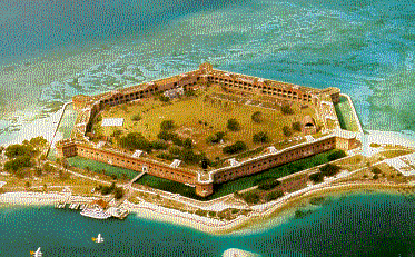
DRY TORTUGAS
The only "allowed" overnight anchorage here is right beside Fort Jefferson.
Anchorage at Garden Key
24 37.469N 082 52.295W
CLICK HERE for the National Park Website and info.
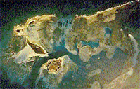
ANCHORAGE in the Tortugas: These keys are 70 miles from Key West in the middle of nothing but the old Fort Jefferson. A good anchorage exists beside Fort Jefferson, which is on Garden Key. The anchorage is just to the SE of Garden Key, between it and Bird Key. This is a national park and overnight anchorage is allowed ONLY in this designated area close to Fort Jefferson. Some of these Islands are off-limits to visitors at various times (bird and turtle nesting). They're supposed to be marked with signs, but these signs fall down and they don't put them back up. The rangers in Fort Jefferson can fill you in. You can dinghy in to the Fort to tour it, and there is a small gift shop and library with interesting things in the fort. The diving and fishing is superb in the Tortugas - check with rangers on where you're allowed to fish. Garden Key light was built before the Loggerhead light, completed in 1825. Later it was incorporated into the structure of Fort Jefferson as it was built. Loggerhead light was built later in 1858 as the primary navigational light. Mooring buoys have been placed along the west side of loggerhead, including the FRENCH WRECK. This steel wreck has depths ranging from the surface to 25 feet - here you'll find a large Jewfish. See the cruising guides for more info.
CHECK Weather carefully before setting out from Key West to the Tortugas. Especially in winter, it can get VERY rough out here with large seas, and it's a LONG way. Make sure that you're self sufficient with water, food and fuel. These are pristine waters for snorkeling and diving.
KEY WEST TO CUBA
RW "KW" MoA Buoy into South Channel of Key West
24 27.676N 081 48.033W
Mariel Hemingway Marina - approach. DeBarlovento Light (RW) about 825 yards out
23 05.358N 082 30.522W
Havana Harbor Approach - about 1/4 mile off harbor entrance. Please note that this is a restricted Harbor - go into Hemingway instead. 23 09.072N 082 21.714W
KEYS OCEANSIDE: Lower Keys
(going from 7mi bridge toward Key West)
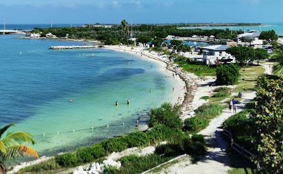
ANCHORAGE in Bahia Honda: (pronounced Bay-uhh Honda). The anchorage is nestled between the old bridge (S. or Ocean side) and the new bridge (N. or Gulf side). Clearance under the new bridge is about 19-20' if you're coming in from the Gulf Side. On the Ocean side part of the old bridge has been cut out on the East end to allow unrestricted passage. Anchor close to the roped off beach between the two bridges. The current gets pretty steep here between tides so anchor well and/or use a Bahamian Moor with two anchors. Don't get up close to the new bridge (N. side) to anchor on this side. We're told there's a lot of junk on the bottom to foul an anchor, but have not confirmed this. Bahia Honda State Park has a small marina basin which contains a nice gift and snack shop. You can dinghy or boat in and tie up at no charge for the day, or dock overnight at a modest charge (don't tie up in front of the shop because the tour boats go out of here). There's also no charge for coming in to the park when you do it this way, but people coming in by car pay admission. There's a nice roped off small beach right beside the anchorage / basin. You can walk up the trail to the top of the old railroad bridge (shown below) which has been fenced off as an observation deck. Dinghy out oceanside and you'll find a couple miles or more of nice beaches on that side of the park. Some of these are hard to access from landside so you can have them to yourself. Dogs are not permitted on the beaches and they get picky about this. Dogs are allowed in the park if you keep them on a leash and stay out of the picnic areas and beach. Though most of the Keys don't really have beaches, Bahia Honda has been reported to be one of the seven best beaches in the United States.
Bahia Honda CLICK HERE for Bahia Honda State Park Website
24 37.150N 081 17.117W
Waypoint is 2 mi straight off of bridge oceanside (used to stay offshore when cruising the Keys)
Picture above shows the old Bahia Honda Bridge at the anchorage - was used for trains and cars prior to the new bridge being built. The small inside beach is shown below. The canal entrance into the marina basin is on the far left. It's starting to shoal in (2019) so even 4' draft might be too much - call them. NOTE: DO NOT cut under the existing spans of the old bridge - even if your boat clears it. The old bridge is falling apart and chunks of steel and concrete can come down on your boat! From oceanside, use ONLY the cutout section for the approach channel. The new bridge on the Gulf side is fine.
Also see Approaches to Bahia Honda from Gulfside listed further down this list, on Gulfside.
Newfound Harbor Approach from East: R50 24 36.736 081 23.590
Newfound Harbor Channel - R2 24 37.117 081 24.419
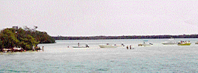
ANCHORAGE in Newfound Harbor: This is a very nice anchorage where we frequently spend weekends. It's a good jumping off point to run back and forth to Looe Key reefs for diving and snorkeling too. (Look at the diving pages for an aerial picture of Looe Key Reef). A "quickie-just-overnight-for-some-protection" anchorage is just inside past Little Palm Island Resort on your starboard side. The better anchorage (to the West side of three islands you see off your port bow as you come in the channel) requires that you loop up and around the islands to approach the anchorage from the North West side. Follow the chart and stay off the shoals - it loops around like a comma. Try anchoring at about 24 38.181N 081 23.742W just off the little island with a sandy beach. You'll be looking at the view below.
CLICK HERE for a Chart view of the anchorage.
CLICK HERE for an information sheet on the anchorage, navigation, nearby restaurants, etc.
(opens as a MS word doc, detailed info and website links)
Dogs are welcome to run free here, as long as they're friendly.
The middle island (your left in this picture) - picnic island - is a hot spot on weekends because of the long sand bar coming off the South side. People bring lawn chairs and cooler and spend the entire day there and on the island. It's a good place for kids and dogs. A pontoon boat may show up to sell soft soft drinks, hot dogs and hamburgers right off the boat!
If you can get someone local to give you pointers on where the canal is, you can dinghy in to the Looe Key Tiki Bar and restaurant for dinner or entertainment from the anchorage here. Boondocks is just across the street. It's a small residential canal just to the NorthWest of the anchorage, which turns and heads straight North after you're in it - up toward US 1 - then turns East in behind the Looe Key Reef Resort and Dive Center. Tie up and enjoy. It's 1.85 nm from the anchorage to the Bar by dinghy route. The entrance daymarks to this canal are at 24 38.803N 081 24.194W. Don't dinghy directly from the anchorage to these daymarks because of the shoal on the West side of the anchorage - curve around to avoid it.
From this anchorage in Newfound Harbor you can also dinghy in to Little Palm Island Resort - just at the entrance to the Harbor (docks at 24 37.444N 081 24.115W). This is an exclusive resort (no kids under 16 or pets allowed). Dockage is expensive but worth it to spend the night, have dinner, and enjoy the resort facilities. - - But no phones or TV at this South Seas Style Tropical Resort. It's one of those "Rich and Famous" type places.
Info on all of this is on the MS Word document listed above on the information sheet.
DIVING - Looe Key Reef. 24 32.730N, 081 24.373W
Great diving and snorkeling reef. Site of annual summer underwater music concert. S.P.A. area so rules apply. Mooring Buoys. 20-25 feet.
SNORKELING - Newfound Harbor Moorings: 24 36.819N, 081 23.438W
Nice shallow reef just west of Newfound Harbor just NE of R50 marker. From 2-10 feet of water. S.P.A. area. Mooring balls. You can dinghy here from Newfound harbor anchorages.
***********
KEYS OCEANSIDE:
Middle Keys - going from 7 mi bridge East to Upper Keys
S. Approach to Money Key Channel - Molasses / Money Keys (S Side of 7 mi Bridge).
24 40.580N 081 11.880W
There "used to be" a good anchorage behind Money Key and the 7 mile bridge. Watch your charts and stay in the channel up to the bridge, then go alongside the bridge to enter the anchorage. HOWEVER - as of 2020 there is still a lot of mangrove debris in that anchorage left over from the last storm. You can see it well enough during the day, but go in at your own risk. Little day boats are still OK going in.
Molasses Key and Anchorage.
Watch your charts and go in from Moser Channel. We stay alongside the bridge until in deeper water just N of the larger Molasses Key and anchor at about 24 41.296N, 081 11.352W. That's in front of the larger island, but we dinghy in to the smaller island just to it's west. In smaller boats you can go right up to the sand flats on the North side of that smaller island. WATCH THE CURRENT in the small channels - it rips. We have anchored the big boat in those, but I'm getting too old for that. It has a scoured bottom with poor holding and fast currents. For us it's better to anchor just North of the larger island with less current and better holding in about 7' of water.
Moser Channel Approach from South (7 mi bridge), R2 24 41.140N 081.10.000W
MOORINGS in Boot Key Harbor -
Boot Key Harbor is a regulated anchorage and has mooring buoys. There are still a few places to anchor but not within the mooring field. Many transients anchor just outside the harbor on the west side of Boot Key when winds allow. You could still dinghy in to Lazy Days restaurant and Burdines Tiki from there. Otherwise contact the City Marina for a mooring buoy.
https://www.ci.marathon.fl.us/marinaandports
Boot Key Harbor is the best protected anchorage in all of the Keys, plus plenty of Marina's, Restaurants and Business to reprovision.
CLICK HERE for a graphical map of local points of interest, restaurants, etc.
Boot Key Harbor Channel West, between G1&R2: 24 41.942N 081 07.226W
Approach to Sister Creek - South entrance to Boot Key Harbor
(1/2 way between channel and E Washerwoman) ( To Boot Key Harbor)
24 40.826N 081 04.615W
Sister Creek, R2 24 41.206N 081 05.220W
W Sister Rock (aka "Gullah Gullah island), 24 41.175N, 081 05.441W
Nice day anchorage to play on the island. Good overnight anchorage if winds and weather are OK. Anchor just to the east of the island. Once you learn the area you can get in closer, south of the island, and watch for a ledge that starts about halfway to the west, just S of the island. Come on the Island from the North side. The south (ocean) side has LOTS of SHARP limestone rocks plus urchins. Don't land from that side.
SNORKELING: On the North and West sides of the Islands in 10' or less are little coral outcroppings to snorkel - lots of Juvenile fish.
SNORKELING: East Washerwoman Shoal: 24 39.936N, 081 04.493W
shallow patch reef nice for snorkeling in about 10 feet and less
DIVING - Delta Shoal - just East of Sombrero Reef. 24 38.021N 081 05.476W
Snorkeling and diving in about 5-15 feet of water. No buoys nor markers. This is outside of the S.P.A. areas so can lobster or spearfish here.
DIVING - Sombrero Reef - 24 37.562N, 081 06.598W S.P.A area
Snorkeling and diving in 10-25 feet of water. Outer buoys are in about 45' water. Marine Sanctuary Special Preservation area so rules apply. Mooring Buoys.
R48 off Key Colony Beach: (on N. Side of Daymark) 24 41.570N 081 01.500W
DIVING - COFFINS PATCH 1: SW Moorings. 24 41.100N, 080 57.849W
Snorkeling Diving in about 7-10 feet of water. Good for new snorkelers.
DIVING - COFFINS PATCH 2: Outside edge of reef. 24 40.508N 080 57.383W
Snorkeling Diving in about 20' of water, sloping to 40+ feet.
DIVING - COFFINS PATCH 3: East side of reef at Elbow. Abt 1mi east of wreck & buoys
Snorkeling Diving in about 10-23' of water.
Duck Key Approach from Hawks Channel - 1 1/3 mi SW of Duck Key Channel
24 44.643N 080 55.317W
Duck Key Channel, R2: 24 45.801 080 54.661
Marina - Hawk's Cay Resort & Marina, on DUCK KEY- Follow the Duck Key channel in from R2 around to the right and all the way to the back - Marina is nestled up close to highway in a basin. Access to all the resorts facilities including multiple pools, jacuzzi's, exercise facilities, 4 restaurants, 2 bars. They monitor VHF 16 and work on 10.
https://www.hawkscay.com/amenities/hawks-cay-marina
R45 E Turtle Shoal: 24 43.739N 080 56.000W
R44 Channel 5, Oceanside. Long Key 24 47.400 080 46.942 (S. Entrance to Channel)
Marina - Caloosa Cove Resort & Marina: 24 50.965N 080 44.268W. At east end of Ch 5 bridge. Follow the small marked channel into this waypoint & marina. Full service marina with fuel, Restaurant and the Safari Lounge next door (known as the dead animal bar to locals - it has stuffed & mounted heads of African wild animals taken during Safari's).
https://caloosacove.com/
Tennessee Reef Light 24 44.700N 080 46.900W
Indian Key Channel - South, from Oceanside 24 52.584N 080 40.215W
Anchorage at Indian Key - 24 52.681N 080 40.807W. This is just to the west of Indian Key in about 5' of water off lower Matecumbe Key about mile marker 78.2 on US1. Provides access to historical Indian Key on oceanside, and Lignum Vitae on gulfside. Very exposed for oceanside wind/waves from SE through SW. Mooring buoys have been placed here by the park service. (Also see Lignum Vitae anchorage under Gulfside upper Keys - it's just across the bridge from here)
CLICK HERE for an info sheet about this destination and surrounding area of Islmorada, regarding bridge clearances, distances, nearby restaurants-bars, things do, etc..
Opens as a MS word doc.
Alligator Light 24 51.100N 080 37.100W
KEYS OCEANSIDE:
Upper Keys (Also look up the Dive Sites for places in the upper Keys)
DIVING: Dry Rocks Reef (Christ of the Abyss) - Pennekamp Park
25 07.361N 080 17.843W
DIVING: R6, Elbow Reef - Pennekamp Park 25 08.700N 080 1.500W
DIVING: Carysfort Light & Reef 25 13.300N 080 12.700W
DIVING: Turtle Reef - Pennekamp Park 25 16.54N 080 12.493W
****************************************************
GULFSIDE: Middle Keys
Between R30/G29, N of Bahia Honda Bridge (gulfside) ICW
24 41.953N 081 16.469W
Bahia Honda Channel (gulfside) - First (Southernmost) approach into channel ( 1st waypoint from ICW) 24 44.140N 081 14.630W
Final approach into channel ( 2nd waypoint from ICW) 24 45.980N 081 16.040W
Moser Channel Approach from North (7 mi bridge), 1/4 mi North of bridge
24 42.305N 081 10.064W
R22 - ICW, N of 7 mi Bridge 24 43.066N 081 09.189W
Between R22/G21 - ICW, N of 7 mi Bridge 24 43.064N 081 09.187
R24 - ICW, N of 7 mi Bridge 24 42.635N 081 11.167W
R26 - ICW, N of 7 mi Bridge 24 42.189N 081 13.310W
Knight’s Key Channel, South Side- between pillars 7-8 on 7 mi bridge
24 42.409N 081 07.630W
Knight’s Key Channel, North Side - between pillars 7-8 on 7 mi bridge
24 42.476N 081 07.585W
Knight’s Key Channel - just E of Shoal Mark, used when heading N/S
24 42.978N 081 07.427W
Knight’s Key Shoal - 1/8 mi N of Shoal Mark, used when heading E/W
24 42.998N 081 07.603W
Faro Blanco Oceanside, approach from West 24 42.881N 081 06.386W
R12, ľ mi West of Red Bay Bank 24 45.299N 081 10.464W
Between R18-G17, Bethel Bank 24 44.339N 081 06.325W
G17, Bullard Bank 24 48.960N 081 09.245W
Rachel Key - Ľ mi North of Key 24 43.867N 081 04.750W
GULFSIDE: Upper Keys
Anchorage at Lignum Vitae: 24 52.681N 080 40.807W just off lower Matecumbe Key at mile marker 78.2 on US1. Directly across bridge from Indian Key on oceanside. Anchor on NW of island. Mooring buoys have been placed here by the park service. The State conducts guided tours twice daily at 10am and 2pm. Low cost if you come to the dock on the E side by your own boat (talk to rangers). You can only dock there at the time of these tours. Nice hardwood hammock and historical island. Lots of mosquitoes reported! - take repellant. CLICK HERE for an info sheet about this destination, regarding bridge clearances, distances, nearby restaurants-bars, things do, etc..
R90 - ICW - West End of Steamboat Channel 24 56.388N 080 40.042W
R86 - ICW - East End of Steamboat Channel 24 56.648N 080 39.547W
Anchorage at Shell Key: 24 55.480N 080 40.215W gulfside, between Lignum Vitae (above) and the Lorelei Restaurant (below). This is a state owned Bird Sanctuary. You are not allowed on the island, but can bird watch from you boat or dinghy. Several mooring buoys have been placed here by the park service. Very exposed from the North. CLICK HERE for an info sheet about this destination, regarding bridge clearances, distances, nearby restaurants-bars, things do, etc..
Anchorage at Islamorada - Lorelei Restaurant & Bar: Islamorada Yacht Basin. 24 55.363N 080 38.169W gulfside, about mile marker 82 off US1. 5' of water here, 6-7' a little further from shore. Exposed from NE to NW winds. This is access to the Lorelei restaurant and Tiki Bar. Live entertainment. Good Seafood. They do have a boat basin there where you can dock in one section (down by the sailboats if open) for no charge (call them first). The Lorelei is about 100 yards North of the tower. Don't dinghy straight in from the anchorage to the docks because of shoals. Look for the small private green daymark & pipe with red stripes about halfway between the tower and the Lorelei. Go through there, then turn to port toward the Lorelei docks. Dogs on a leash are OK at the bar, but there are lots of cats around. You can also dinghy over to the WorldWide Sportsman (Gigantic Fish & Tackle Shop with Hemingway's boat inside) and the Islamorada Fish Company Restaurant which are both inside the shallow bay just to the SW of the Lorelei anchorage.
R78a - ICW around Plantation Yacht Harbor (PYH) 24 58.863N 080 35.969W
Plantation Yacht Harbor Approach (start of turn off ICW between R78a and R78)
24 59.461N 080 34.374W
Plantation Yacht Harbor Entrance - right off breakwall 24 58.107N 080 34.086W
This is a very comfortable Marina. Owned by the city of Islamorada. You can still get dockage here but no restaurant/bar.. Not much around the Marina within walking distance.
Grouper Creek - S. Entrance - ICW 25 07.277N 080 26.774W
Dusenbury Creek - North Side - ICW 25 08.642N 080 25.430W
R2 - South of Cape Sable, just W of 1st National Bank Shoals: 25 05.00N 080 04.98W
Flamingo Lodge Channel Entrance, G9 25.07.419N 080.55.789W
(NOTE FLAMINGO LODGE STILL CLOSED AS OF 2020)
Flamingo Lodge & Marina - Everglades National Park. This is a very nice marina and lodge right in the middle of the everglades. A Park Ranger station is located at the lodge. They have a screened in swimming pool and a restaurant. Friends can drive there from Florida City.
South Florida - West Coast - heading South
Cape Romano - 9 miles West of Cape, to avoid near shore shoals
25 52.600N 081 52.000W
San Carlos Light 26 25.100N 081 57.500W
Cape Sable - 2 miles West of R4 25 12.780N 081 13.820W
Shark River Approach - ľ mi West of River (little shark river) 25 19.110N 081 10.200W
Shark River G1 (little shark river) & Tarpon Bay 25 19.327N 081 09.222W
ANCHORAGE IN EVERGLADES NATIONAL PARK
Good overnight anchorage just inside the channel (see cruising guides) - Great anchorages about 10 miles up the river in Tarpon Bay. Make sure you have the charts all the way up the river into Tarpon Bay - otherwise there's a good chance you'll get lost trying to come back out. You can carry 6' at high tide up the river. Watch out for mosquitoes and alligators!
NOTE: A Special Boaters Education Permit is now required for all boats cruising or anchoring in the Everglades national park area.
**********************************************************************************************
TORTUGAS TO KEY WEST and MIAMI
Courtesy - Marathon Power Squadron, a unit of the United States Power Squadron
PLEASE CHECK OTHER SOURCES FOR ANY UPDATES
THIS INFORMATION IS NOT ROUTINELY MONITORED
These waypoints MUST be used only in conjunction with current charts of the area, and cross checked against other navigational methods such as soundings, navigational aids and bearings. Do not rely solely upon these waypoints, and don't use them at all unless you are able to fully navigate yourself. You are responsible for your own navigation. US Power Squadron members may additionally contact the Port Captains in various areas for additional information.
DRY TORTUGAS
The only "allowed" overnight anchorage here is right beside Fort Jefferson.
Anchorage at Garden Key
24 37.469N 082 52.295W
CLICK HERE for the National Park Website and info.
ANCHORAGE in the Tortugas: These keys are 70 miles from Key West in the middle of nothing but the old Fort Jefferson. A good anchorage exists beside Fort Jefferson, which is on Garden Key. The anchorage is just to the SE of Garden Key, between it and Bird Key. This is a national park and overnight anchorage is allowed ONLY in this designated area close to Fort Jefferson. Some of these Islands are off-limits to visitors at various times (bird and turtle nesting). They're supposed to be marked with signs, but these signs fall down and they don't put them back up. The rangers in Fort Jefferson can fill you in. You can dinghy in to the Fort to tour it, and there is a small gift shop and library with interesting things in the fort. The diving and fishing is superb in the Tortugas - check with rangers on where you're allowed to fish. Garden Key light was built before the Loggerhead light, completed in 1825. Later it was incorporated into the structure of Fort Jefferson as it was built. Loggerhead light was built later in 1858 as the primary navigational light. Mooring buoys have been placed along the west side of loggerhead, including the FRENCH WRECK. This steel wreck has depths ranging from the surface to 25 feet - here you'll find a large Jewfish. See the cruising guides for more info.
CHECK Weather carefully before setting out from Key West to the Tortugas. Especially in winter, it can get VERY rough out here with large seas, and it's a LONG way. Make sure that you're self sufficient with water, food and fuel. These are pristine waters for snorkeling and diving.
KEY WEST TO CUBA
RW "KW" MoA Buoy into South Channel of Key West
24 27.676N 081 48.033W
Mariel Hemingway Marina - approach. DeBarlovento Light (RW) about 825 yards out
23 05.358N 082 30.522W
Havana Harbor Approach - about 1/4 mile off harbor entrance. Please note that this is a restricted Harbor - go into Hemingway instead. 23 09.072N 082 21.714W
KEYS OCEANSIDE: Lower Keys
(going from 7mi bridge toward Key West)
ANCHORAGE in Bahia Honda: (pronounced Bay-uhh Honda). The anchorage is nestled between the old bridge (S. or Ocean side) and the new bridge (N. or Gulf side). Clearance under the new bridge is about 19-20' if you're coming in from the Gulf Side. On the Ocean side part of the old bridge has been cut out on the East end to allow unrestricted passage. Anchor close to the roped off beach between the two bridges. The current gets pretty steep here between tides so anchor well and/or use a Bahamian Moor with two anchors. Don't get up close to the new bridge (N. side) to anchor on this side. We're told there's a lot of junk on the bottom to foul an anchor, but have not confirmed this. Bahia Honda State Park has a small marina basin which contains a nice gift and snack shop. You can dinghy or boat in and tie up at no charge for the day, or dock overnight at a modest charge (don't tie up in front of the shop because the tour boats go out of here). There's also no charge for coming in to the park when you do it this way, but people coming in by car pay admission. There's a nice roped off small beach right beside the anchorage / basin. You can walk up the trail to the top of the old railroad bridge (shown below) which has been fenced off as an observation deck. Dinghy out oceanside and you'll find a couple miles or more of nice beaches on that side of the park. Some of these are hard to access from landside so you can have them to yourself. Dogs are not permitted on the beaches and they get picky about this. Dogs are allowed in the park if you keep them on a leash and stay out of the picnic areas and beach. Though most of the Keys don't really have beaches, Bahia Honda has been reported to be one of the seven best beaches in the United States.
Bahia Honda CLICK HERE for Bahia Honda State Park Website
24 37.150N 081 17.117W
Waypoint is 2 mi straight off of bridge oceanside (used to stay offshore when cruising the Keys)
Picture above shows the old Bahia Honda Bridge at the anchorage - was used for trains and cars prior to the new bridge being built. The small inside beach is shown below. The canal entrance into the marina basin is on the far left. It's starting to shoal in (2019) so even 4' draft might be too much - call them. NOTE: DO NOT cut under the existing spans of the old bridge - even if your boat clears it. The old bridge is falling apart and chunks of steel and concrete can come down on your boat! From oceanside, use ONLY the cutout section for the approach channel. The new bridge on the Gulf side is fine.
Also see Approaches to Bahia Honda from Gulfside listed further down this list, on Gulfside.
Newfound Harbor Approach from East: R50 24 36.736 081 23.590
Newfound Harbor Channel - R2 24 37.117 081 24.419
ANCHORAGE in Newfound Harbor: This is a very nice anchorage where we frequently spend weekends. It's a good jumping off point to run back and forth to Looe Key reefs for diving and snorkeling too. (Look at the diving pages for an aerial picture of Looe Key Reef). A "quickie-just-overnight-for-some-protection" anchorage is just inside past Little Palm Island Resort on your starboard side. The better anchorage (to the West side of three islands you see off your port bow as you come in the channel) requires that you loop up and around the islands to approach the anchorage from the North West side. Follow the chart and stay off the shoals - it loops around like a comma. Try anchoring at about 24 38.181N 081 23.742W just off the little island with a sandy beach. You'll be looking at the view below.
CLICK HERE for a Chart view of the anchorage.
CLICK HERE for an information sheet on the anchorage, navigation, nearby restaurants, etc.
(opens as a MS word doc, detailed info and website links)
Dogs are welcome to run free here, as long as they're friendly.
The middle island (your left in this picture) - picnic island - is a hot spot on weekends because of the long sand bar coming off the South side. People bring lawn chairs and cooler and spend the entire day there and on the island. It's a good place for kids and dogs. A pontoon boat may show up to sell soft soft drinks, hot dogs and hamburgers right off the boat!
If you can get someone local to give you pointers on where the canal is, you can dinghy in to the Looe Key Tiki Bar and restaurant for dinner or entertainment from the anchorage here. Boondocks is just across the street. It's a small residential canal just to the NorthWest of the anchorage, which turns and heads straight North after you're in it - up toward US 1 - then turns East in behind the Looe Key Reef Resort and Dive Center. Tie up and enjoy. It's 1.85 nm from the anchorage to the Bar by dinghy route. The entrance daymarks to this canal are at 24 38.803N 081 24.194W. Don't dinghy directly from the anchorage to these daymarks because of the shoal on the West side of the anchorage - curve around to avoid it.
From this anchorage in Newfound Harbor you can also dinghy in to Little Palm Island Resort - just at the entrance to the Harbor (docks at 24 37.444N 081 24.115W). This is an exclusive resort (no kids under 16 or pets allowed). Dockage is expensive but worth it to spend the night, have dinner, and enjoy the resort facilities. - - But no phones or TV at this South Seas Style Tropical Resort. It's one of those "Rich and Famous" type places.
Info on all of this is on the MS Word document listed above on the information sheet.
DIVING - Looe Key Reef. 24 32.730N, 081 24.373W
Great diving and snorkeling reef. Site of annual summer underwater music concert. S.P.A. area so rules apply. Mooring Buoys. 20-25 feet.
SNORKELING - Newfound Harbor Moorings: 24 36.819N, 081 23.438W
Nice shallow reef just west of Newfound Harbor just NE of R50 marker. From 2-10 feet of water. S.P.A. area. Mooring balls. You can dinghy here from Newfound harbor anchorages.
***********
KEYS OCEANSIDE:
Middle Keys - going from 7 mi bridge East to Upper Keys
S. Approach to Money Key Channel - Molasses / Money Keys (S Side of 7 mi Bridge).
24 40.580N 081 11.880W
There "used to be" a good anchorage behind Money Key and the 7 mile bridge. Watch your charts and stay in the channel up to the bridge, then go alongside the bridge to enter the anchorage. HOWEVER - as of 2020 there is still a lot of mangrove debris in that anchorage left over from the last storm. You can see it well enough during the day, but go in at your own risk. Little day boats are still OK going in.
Molasses Key and Anchorage.
Watch your charts and go in from Moser Channel. We stay alongside the bridge until in deeper water just N of the larger Molasses Key and anchor at about 24 41.296N, 081 11.352W. That's in front of the larger island, but we dinghy in to the smaller island just to it's west. In smaller boats you can go right up to the sand flats on the North side of that smaller island. WATCH THE CURRENT in the small channels - it rips. We have anchored the big boat in those, but I'm getting too old for that. It has a scoured bottom with poor holding and fast currents. For us it's better to anchor just North of the larger island with less current and better holding in about 7' of water.
Moser Channel Approach from South (7 mi bridge), R2 24 41.140N 081.10.000W
MOORINGS in Boot Key Harbor -
Boot Key Harbor is a regulated anchorage and has mooring buoys. There are still a few places to anchor but not within the mooring field. Many transients anchor just outside the harbor on the west side of Boot Key when winds allow. You could still dinghy in to Lazy Days restaurant and Burdines Tiki from there. Otherwise contact the City Marina for a mooring buoy.
https://www.ci.marathon.fl.us/marinaandports
Boot Key Harbor is the best protected anchorage in all of the Keys, plus plenty of Marina's, Restaurants and Business to reprovision.
CLICK HERE for a graphical map of local points of interest, restaurants, etc.
Boot Key Harbor Channel West, between G1&R2: 24 41.942N 081 07.226W
Approach to Sister Creek - South entrance to Boot Key Harbor
(1/2 way between channel and E Washerwoman) ( To Boot Key Harbor)
24 40.826N 081 04.615W
Sister Creek, R2 24 41.206N 081 05.220W
W Sister Rock (aka "Gullah Gullah island), 24 41.175N, 081 05.441W
Nice day anchorage to play on the island. Good overnight anchorage if winds and weather are OK. Anchor just to the east of the island. Once you learn the area you can get in closer, south of the island, and watch for a ledge that starts about halfway to the west, just S of the island. Come on the Island from the North side. The south (ocean) side has LOTS of SHARP limestone rocks plus urchins. Don't land from that side.
SNORKELING: On the North and West sides of the Islands in 10' or less are little coral outcroppings to snorkel - lots of Juvenile fish.
SNORKELING: East Washerwoman Shoal: 24 39.936N, 081 04.493W
shallow patch reef nice for snorkeling in about 10 feet and less
DIVING - Delta Shoal - just East of Sombrero Reef. 24 38.021N 081 05.476W
Snorkeling and diving in about 5-15 feet of water. No buoys nor markers. This is outside of the S.P.A. areas so can lobster or spearfish here.
DIVING - Sombrero Reef - 24 37.562N, 081 06.598W S.P.A area
Snorkeling and diving in 10-25 feet of water. Outer buoys are in about 45' water. Marine Sanctuary Special Preservation area so rules apply. Mooring Buoys.
R48 off Key Colony Beach: (on N. Side of Daymark) 24 41.570N 081 01.500W
DIVING - COFFINS PATCH 1: SW Moorings. 24 41.100N, 080 57.849W
Snorkeling Diving in about 7-10 feet of water. Good for new snorkelers.
DIVING - COFFINS PATCH 2: Outside edge of reef. 24 40.508N 080 57.383W
Snorkeling Diving in about 20' of water, sloping to 40+ feet.
DIVING - COFFINS PATCH 3: East side of reef at Elbow. Abt 1mi east of wreck & buoys
Snorkeling Diving in about 10-23' of water.
Duck Key Approach from Hawks Channel - 1 1/3 mi SW of Duck Key Channel
24 44.643N 080 55.317W
Duck Key Channel, R2: 24 45.801 080 54.661
Marina - Hawk's Cay Resort & Marina, on DUCK KEY- Follow the Duck Key channel in from R2 around to the right and all the way to the back - Marina is nestled up close to highway in a basin. Access to all the resorts facilities including multiple pools, jacuzzi's, exercise facilities, 4 restaurants, 2 bars. They monitor VHF 16 and work on 10.
https://www.hawkscay.com/amenities/hawks-cay-marina
R45 E Turtle Shoal: 24 43.739N 080 56.000W
R44 Channel 5, Oceanside. Long Key 24 47.400 080 46.942 (S. Entrance to Channel)
Marina - Caloosa Cove Resort & Marina: 24 50.965N 080 44.268W. At east end of Ch 5 bridge. Follow the small marked channel into this waypoint & marina. Full service marina with fuel, Restaurant and the Safari Lounge next door (known as the dead animal bar to locals - it has stuffed & mounted heads of African wild animals taken during Safari's).
https://caloosacove.com/
Tennessee Reef Light 24 44.700N 080 46.900W
Indian Key Channel - South, from Oceanside 24 52.584N 080 40.215W
Anchorage at Indian Key - 24 52.681N 080 40.807W. This is just to the west of Indian Key in about 5' of water off lower Matecumbe Key about mile marker 78.2 on US1. Provides access to historical Indian Key on oceanside, and Lignum Vitae on gulfside. Very exposed for oceanside wind/waves from SE through SW. Mooring buoys have been placed here by the park service. (Also see Lignum Vitae anchorage under Gulfside upper Keys - it's just across the bridge from here)
CLICK HERE for an info sheet about this destination and surrounding area of Islmorada, regarding bridge clearances, distances, nearby restaurants-bars, things do, etc..
Opens as a MS word doc.
Alligator Light 24 51.100N 080 37.100W
KEYS OCEANSIDE:
Upper Keys (Also look up the Dive Sites for places in the upper Keys)
DIVING: Dry Rocks Reef (Christ of the Abyss) - Pennekamp Park
25 07.361N 080 17.843W
DIVING: R6, Elbow Reef - Pennekamp Park 25 08.700N 080 1.500W
DIVING: Carysfort Light & Reef 25 13.300N 080 12.700W
DIVING: Turtle Reef - Pennekamp Park 25 16.54N 080 12.493W
****************************************************
GULFSIDE: Middle Keys
Between R30/G29, N of Bahia Honda Bridge (gulfside) ICW
24 41.953N 081 16.469W
Bahia Honda Channel (gulfside) - First (Southernmost) approach into channel ( 1st waypoint from ICW) 24 44.140N 081 14.630W
Final approach into channel ( 2nd waypoint from ICW) 24 45.980N 081 16.040W
Moser Channel Approach from North (7 mi bridge), 1/4 mi North of bridge
24 42.305N 081 10.064W
R22 - ICW, N of 7 mi Bridge 24 43.066N 081 09.189W
Between R22/G21 - ICW, N of 7 mi Bridge 24 43.064N 081 09.187
R24 - ICW, N of 7 mi Bridge 24 42.635N 081 11.167W
R26 - ICW, N of 7 mi Bridge 24 42.189N 081 13.310W
Knight’s Key Channel, South Side- between pillars 7-8 on 7 mi bridge
24 42.409N 081 07.630W
Knight’s Key Channel, North Side - between pillars 7-8 on 7 mi bridge
24 42.476N 081 07.585W
Knight’s Key Channel - just E of Shoal Mark, used when heading N/S
24 42.978N 081 07.427W
Knight’s Key Shoal - 1/8 mi N of Shoal Mark, used when heading E/W
24 42.998N 081 07.603W
Faro Blanco Oceanside, approach from West 24 42.881N 081 06.386W
R12, ľ mi West of Red Bay Bank 24 45.299N 081 10.464W
Between R18-G17, Bethel Bank 24 44.339N 081 06.325W
G17, Bullard Bank 24 48.960N 081 09.245W
Rachel Key - Ľ mi North of Key 24 43.867N 081 04.750W
GULFSIDE: Upper Keys
Anchorage at Lignum Vitae: 24 52.681N 080 40.807W just off lower Matecumbe Key at mile marker 78.2 on US1. Directly across bridge from Indian Key on oceanside. Anchor on NW of island. Mooring buoys have been placed here by the park service. The State conducts guided tours twice daily at 10am and 2pm. Low cost if you come to the dock on the E side by your own boat (talk to rangers). You can only dock there at the time of these tours. Nice hardwood hammock and historical island. Lots of mosquitoes reported! - take repellant. CLICK HERE for an info sheet about this destination, regarding bridge clearances, distances, nearby restaurants-bars, things do, etc..
R90 - ICW - West End of Steamboat Channel 24 56.388N 080 40.042W
R86 - ICW - East End of Steamboat Channel 24 56.648N 080 39.547W
Anchorage at Shell Key: 24 55.480N 080 40.215W gulfside, between Lignum Vitae (above) and the Lorelei Restaurant (below). This is a state owned Bird Sanctuary. You are not allowed on the island, but can bird watch from you boat or dinghy. Several mooring buoys have been placed here by the park service. Very exposed from the North. CLICK HERE for an info sheet about this destination, regarding bridge clearances, distances, nearby restaurants-bars, things do, etc..
Anchorage at Islamorada - Lorelei Restaurant & Bar: Islamorada Yacht Basin. 24 55.363N 080 38.169W gulfside, about mile marker 82 off US1. 5' of water here, 6-7' a little further from shore. Exposed from NE to NW winds. This is access to the Lorelei restaurant and Tiki Bar. Live entertainment. Good Seafood. They do have a boat basin there where you can dock in one section (down by the sailboats if open) for no charge (call them first). The Lorelei is about 100 yards North of the tower. Don't dinghy straight in from the anchorage to the docks because of shoals. Look for the small private green daymark & pipe with red stripes about halfway between the tower and the Lorelei. Go through there, then turn to port toward the Lorelei docks. Dogs on a leash are OK at the bar, but there are lots of cats around. You can also dinghy over to the WorldWide Sportsman (Gigantic Fish & Tackle Shop with Hemingway's boat inside) and the Islamorada Fish Company Restaurant which are both inside the shallow bay just to the SW of the Lorelei anchorage.
R78a - ICW around Plantation Yacht Harbor (PYH) 24 58.863N 080 35.969W
Plantation Yacht Harbor Approach (start of turn off ICW between R78a and R78)
24 59.461N 080 34.374W
Plantation Yacht Harbor Entrance - right off breakwall 24 58.107N 080 34.086W
This is a very comfortable Marina. Owned by the city of Islamorada. You can still get dockage here but no restaurant/bar.. Not much around the Marina within walking distance.
Grouper Creek - S. Entrance - ICW 25 07.277N 080 26.774W
Dusenbury Creek - North Side - ICW 25 08.642N 080 25.430W
R2 - South of Cape Sable, just W of 1st National Bank Shoals: 25 05.00N 080 04.98W
Flamingo Lodge Channel Entrance, G9 25.07.419N 080.55.789W
(NOTE FLAMINGO LODGE STILL CLOSED AS OF 2020)
Flamingo Lodge & Marina - Everglades National Park. This is a very nice marina and lodge right in the middle of the everglades. A Park Ranger station is located at the lodge. They have a screened in swimming pool and a restaurant. Friends can drive there from Florida City.
South Florida - West Coast - heading South
Cape Romano - 9 miles West of Cape, to avoid near shore shoals
25 52.600N 081 52.000W
San Carlos Light 26 25.100N 081 57.500W
Cape Sable - 2 miles West of R4 25 12.780N 081 13.820W
Shark River Approach - ľ mi West of River (little shark river) 25 19.110N 081 10.200W
Shark River G1 (little shark river) & Tarpon Bay 25 19.327N 081 09.222W
ANCHORAGE IN EVERGLADES NATIONAL PARK
Good overnight anchorage just inside the channel (see cruising guides) - Great anchorages about 10 miles up the river in Tarpon Bay. Make sure you have the charts all the way up the river into Tarpon Bay - otherwise there's a good chance you'll get lost trying to come back out. You can carry 6' at high tide up the river. Watch out for mosquitoes and alligators!
NOTE: A Special Boaters Education Permit is now required for all boats cruising or anchoring in the Everglades national park area.
**********************************************************************************************